
Minnesota is no stranger to brutal summers, but the final days of June 2026 have served up a stretch of heat and humidity that has put residents across the state on high alert. With temperatures soaring into the mid-to-upper 90s, heat index readings pushing past 100 degrees in several areas, and a rotating cycle of storm chances on the horizon, this is a weather pattern that demands attention — and preparation. Here is a clear-eyed breakdown of what is happening, what is coming, and how to stay safe through it all.
A Heat Wave That Refuses to Let Go
The current heat event across Minnesota is not a one-day spike. It is a sustained, multiday pattern driven by upper-level high pressure that has locked oppressive air in place over much of the Upper Midwest. Southwesterly winds have been pulling moisture north from the Gulf of Mexico, sending dew points into the low-to-mid 70s — levels that make the human body work overtime just to stay cool.
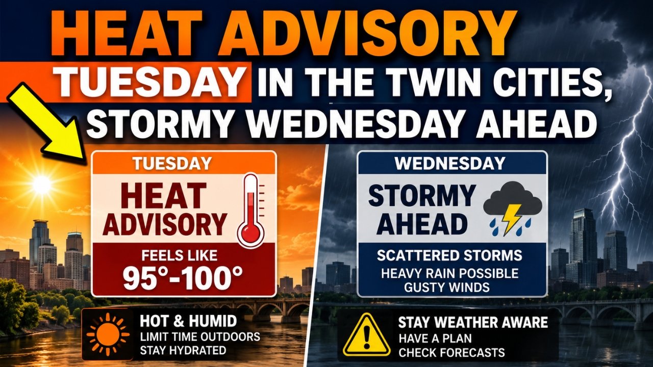
The Twin Cities metro has seen temperatures climb to around 97°F, with heat index values — what the temperature actually feels like when humidity is factored in — ranging between 100°F and 110°F across the southern half of the state. The National Weather Service issued an Extreme Heat Warning for central, east-central, south-central, and southeastern Minnesota, while a broader Heat Advisory covered most of the southern two-thirds of the state. These are not routine advisories. When the body cannot efficiently shed heat, the risk of heat exhaustion and heat stroke rises sharply — and it can happen faster than people expect.
Humidity on the Way Down, But Heat Stays Put
One meaningful shift taking shape as we move into early July is a modest easing of the most extreme moisture levels. While temperatures will remain firmly in the upper 80s to low 90s, dew points are expected to back off from the oppressive mid-to-upper 70s seen in late June toward the more manageable upper 60s. That is still uncomfortable, but it gives the body more ability to cool through sweat evaporation — a meaningful difference when you are spending time outdoors.
The table below outlines the general forecast picture across key periods:
| Period | High Temp (°F) | Dew Point (°F) | Heat Index (°F) | Storm Chance |
|---|---|---|---|---|
| Monday–Tuesday (Late June) | 93–97 | 72–76 | 100–110 | Low–Moderate |
| Wednesday–Thursday (July 2) | 88–93 | 68–72 | 95–103 | Moderate–High |
| Friday–Saturday (July 4 Weekend) | 85–90 | 64–69 | 90–97 | Moderate |
| Sunday–Early Week | 80–87 | 60–65 | 82–90 | Lower |
Temperatures are finally expected to ease slightly into the 80s by the end of the holiday weekend and the start of the following week, offering the first real break from the relentless heat. That is welcome news, though it comes with its own caveat — the transition periods are when some of the most active storm development tends to occur.
Storm Chances Build Into the Holiday Weekend
The stormy side of this forecast is equally worth tracking. As frontal boundaries push through the region, they act as triggers for thunderstorm development — and with this much moisture in the atmosphere, storms that do form have plenty of fuel. A line of showers and thunderstorms was expected to push through Wednesday evening, with some storms carrying a risk of damaging winds and hail. The severe weather threat, while not extreme, is real enough to take seriously.
Looking ahead to the Fourth of July holiday weekend, storm chances remain woven into the pattern on Friday and Saturday. Saturday, in particular, stands out as a day when shower and storm activity could be most widespread, which has implications for anyone planning outdoor celebrations. The storms are expected to carry a primary threat of damaging wind gusts — meteorologists have flagged gusts in the 60 to 75+ mph range as possible with the strongest cells — along with the possibility of large hail. A brief tornado cannot be entirely ruled out with any supercell-type storm that develops.
Protecting Yourself During Dangerous Heat
Heat is consistently one of the deadliest weather-related hazards in the United States, precisely because it is easy to underestimate. The body’s core temperature can rise faster than most people realize, particularly in high-humidity conditions where sweat does not evaporate effectively.
The CDC’s guidance is straightforward and worth repeating: drink water consistently throughout the day, even before you feel thirsty. Avoid alcohol, caffeine, and sugary beverages during peak heat, as they can accelerate dehydration. Opt for loose-fitting, light-colored clothing that helps reflect heat rather than absorb it. Limit strenuous outdoor activity to the early morning or evening hours when temperatures are lower. Pay close attention to vulnerable people around you — the elderly, young children, those with chronic health conditions, and people who work or exercise outdoors face the greatest risk. Public cooling centers, libraries, shopping malls, and movie theaters all provide reliable air-conditioned spaces if your home is not adequately cooled.
Gradual Relief on the Horizon
The good news, if you can hold on long enough to reach it, is that the larger atmospheric pattern shows signs of relaxing by early next week. The ridge of high pressure responsible for trapping the heat in place is forecast to shift, allowing a cooler and less humid air mass to work into the Upper Midwest. Highs are expected to drop into the lower 80s, with dew points in the comfortable 60s — a dramatic improvement after more than a week of punishing conditions.
Storm chances are likely to diminish alongside the temperature drop, giving the region a chance to breathe. June 2026 is on track to finish warmer than average for Minnesota, and the opening days of July have continued that trend. Keep checking local forecasts and National Weather Service alerts as this pattern evolves, since storm timing and temperatures can shift meaningfully within 24 to 48 hours.
Frequently Asked Questions
Q: When will the humidity in Minnesota finally drop?
A: Dew points are expected to ease from oppressive levels (mid-70s) to more manageable levels (upper 60s) by Wednesday or Thursday, with more comfortable air arriving by early the following week.
Q: Is there a risk of severe storms around the Fourth of July?
A: Yes. Storm chances exist through much of the holiday weekend, with Saturday carrying the highest risk. Damaging winds and hail are the primary threats.
Q: What is a heat index and why does it matter?
A: The heat index combines air temperature and humidity to reflect how hot it actually feels to the human body. High humidity prevents sweat from evaporating, making the body feel significantly hotter than the thermometer reading.
Q: What are the early warning signs of heat exhaustion?
A: Watch for heavy sweating, muscle cramps, weakness, dizziness, headache, nausea, and pale or clammy skin. Move to a cool place immediately and hydrate. If symptoms worsen or heat stroke is suspected, call 911.